Articles by "California"
Abraham Hostels Abraham Tours Angkor Wat Anza-Borrego Arizona astrophotography Austria Avenches Baja California Sur Barstow Bern Bethlehem Bishop Borrego Springs Budapest Buellton Caledonian Canal Caledonian Discovery California Cambodia Caribbean castles Central California Chania Chicago Christmas Christmas markets Civil War Clearwater Colorado Conejo Valley Crete customs Dana Point Dead Sea Death Valley Denver dog friendly Dublin Eastern California Edinburgh El Paso Essigbrätlein Europe European river cruise Flagstaff Florida Food Tour food travel Georgia (Country) Gergeti Trinity Church Germany golf goTenna Gothenburg Grand Canyon Greece Hanoi Highway 395 Hike Hostel hotel review Hungary Illinois Ireland Israel jet lag Kakheti Kansas Kingman Kiruna La Paz Lake Geneva Lausanne layover Louisiana Lucerne luxury travel Luzern Maine Mammoth Lakes Manassas Mexico Michelin Middle East Missouri Monarch Beach Golf Links Moosehead Lake Moosehead Pinnacle Pursuit Munich Murten New Mexico New Orleans New Year's Eve New Zealand night photography Nuremberg Oklahoma Orange County Oregon Oregon City Oregon's Mt. Hood Territory other packing Palestine Photography Photos Prince William County Puerto Penasco Puerto Rico review road trip Route 66 Salton Sea San Diego San Diego Travel & Adventure Show Scotland Scotland Cruise Scotland Highlands Scottish Highlands Sighnaghi Southern California St. Petersburg St. Regis Monarch Beach Sunrise Sweden Swedish Lapland Switzerland Tbilisi Tel Aviv Texas Thailand things to do in Denver Tijuana travel tips United Kingdom Vietnam Viking Ocean Cruises Viking River Cruises Virginia Volaris walking tours weekend getaway Wildflowers winter travel Yuma Zurich

Racetrack Playa 3-Day Death Valley Road Trip Itinerary

Death Valley is the largest U.S. National Park within the contiguous United States.  Death Valley is located in eastern California and has valleys, mountains, canyons, salt flats, sand dunes, and oases.  Death Valley also has almost 1,000 miles of paved and dirt roads, so is a multi-day road trip within itself.  There are so many outdoor adventures to be had in Death Valley.  Here are some of the best things to do in Death Valley to put together a full three-day road trip itinerary, including some off-road exploration.

Death Valley Attractions


Badwater Basin


Badwater Basin Death Valley Road Trip Itinerary

Badwater Basin is the lowest point in North America, at 282 feet below sea level.  The Badwater Basin salt flats cover almost 200 square miles.  Salt flats occur when there is an enclosed basin that doesn’t drain to the sea, a source of salts, and an arid climate where more evaporation than precipitation occurs.  A thin upper crust of salt forms over a mud layer below and salt crystals form along the cracks.

Devils Golf Course


Devils Golf Course Death Valley Road Trip Itinerary

Devils Golf Course isn’t a real golf course (see further down for information about Death Valley’s golf course).  It got its name from a line in the 1934 National Park Service guide book which said, “Only the devil could play golf” there.  The jagged landscape is created by crystallized salt formations created by ancient salt lakes, wind, and rain.  When it’s warm, the expansion and contraction of the salt pinnacles create metallic cracking sounds.  The drive out to Devils Golf Course is along a dirt road.

Natural Bridge Canyon


Natural Bridge Canyon Death Valley Road Trip Itinerary

Natural Bridge Canyon was carved by a stream.  A fin of rock formed by a sharp bend in the stream eventually had a hole punched into it by pounding floods, creating the 35-foot thick and 35-foot high natural bridge that connects the walls of the canyons.  The natural bridge is found about one-third of a mile into the hike, but beyond that there are some other interesting geological formations like dripping mud that looks like wax, hanging canyons, and dry waterfalls.  The drive up to National Bridge Canyon is a pretty bumpy dirt road.

Mesquite Flat Sand Dunes


Mesquite Flat Sand Dunes Death Valley Road Trip Itinerary

Death Valley National Park has five sand dunes: Mesquite Flat Dunes, Eureka Dunes, Saline Valley Dunes, Panamint Dunes, and Ibex Dunes.  Eureka Dunes are the tallest in California, but Mesquite Flat Dunes are the best known and easiest to get to in the park.  Mesquite Flat Dunes are even easy to visit at night for astrophotography. 

Artist’s Drive


Artist's Drive Death Valley Road Trip Itinerary

Artist’s Drive is a nine-mile paved road that winds through multi-colored volcanic and sedimentary badlands.  This is an especially nice drive for those that can’t take some of Death Valley National Park’s off-roading trails.  There are a few stops along the way, including the colorful artist’s palette. 

Salt Creek Trail


Salt Creek Trail Death Valley Road Trip Itinerary

Salt Creek is a desert oasis situated more than 200 feet below sea level.  Salt Creek is the home of the rare Salt Creek Pupfish which thrives in the salty water.  A quarter-mile boardwalk follows along the creek to create Salt Creek Trail.

Keane Wonder Mine


Keane Wonder Mine Death Valley Road Trip Itinerary

Keane Wonder Mine was one of the few profitable mines in Death Valley.  The mine was discovered by Jack Keane and Domingo Etcharren in 1904 and it produced over a million dollars in gold from 1904 to 1917.  It is one of the best examples of a mine in the national park.  A unique feature of the mine is an aerial tramway used to carry gold ore from the mine to the mill.  Kean Wonder Mine only recently reopened in November 2017 after having been closed to the public since 2008.

Zabriskie Point


Zabriskie Point Death Valley Road Trip Itinerary

Zabriskie Point is a favorite spot for sunrises and sunsets because of how the badlands capture and reflect the golden and reddish hues.

Ubehebe Crater


Ubehebe Crater Death Valley Road Trip Itinerary

Ubehebe Crater is a half-mile across and 500 feet deep.  The crater was created by a massive explosion that occurred around 2,000 years ago.

Furnace Creek Golf Course


Furnace Creek Golf Course Death Valley Road Trip Itinerary

Furnace Creek Golf Course isn’t one of Death Valley’s natural outdoor attractions, but it is a pretty cool outdoor attraction nonetheless.  Furnace Creek Golf Course is the lowest elevation golf course in the world, at 214 feet below sea level.  The greens are covered with a fine layer of crusty salt, easily mistaken at first for sand.  It’s surprising that grass can grow here at all.  The 19th Hole Bar & Grill has a drive-through ramp for golf carts, a fun and unusual feature for a golf course.  Because Furnace Creek Golf Course appears in guidebooks as a unique destination because of it being the lowest elevation golf course in the world, people from all over the world come here to play a round of golf . . . even if they’ve never played golf before in their life.  We literally overheard a guest ask a golf shop employee if the ball goes on top of the tee.  But if you can get out on the course before the novice golfers, it’s a fun round of golf.  Beware that at such a low elevation, the golf ball doesn’t go as far.  The golf course is pretty flat, but it’s completely surrounded by mountains, and surprisingly there are some water features as well.

Death Valley Off-Road Adventures


Racetrack Playa


Racetrack Playa Death Valley Road Trip Itinerary

One of the most fascinating spots in Death Valley is Racetrack Playa, a dry lakebed dotted with random rocks with trails that stretch behind them.  The tracks prove that the rocks move, but how was a mystery until very recently.  Scientists discovered through monitoring the rocks that when there is enough rain, the playa becomes a shallow lake.  In the winter, the surface freezes into a sheet of floating ice.  The ice sheets break in the morning and breezes push the floating ice sheets along with their embedded rocks.  When the ice melts and the water evaporates, the rocks are left in their new locations until this happens again, perhaps years later.  The trip out to Racetrack Playa is a pretty hairy 27-mile rough dirt road with jagged rocks.  A high-clearance vehicle with heavy-duty tires is necessary to make the two-and-a-half hour drive out to the playa.

Titus Canyon
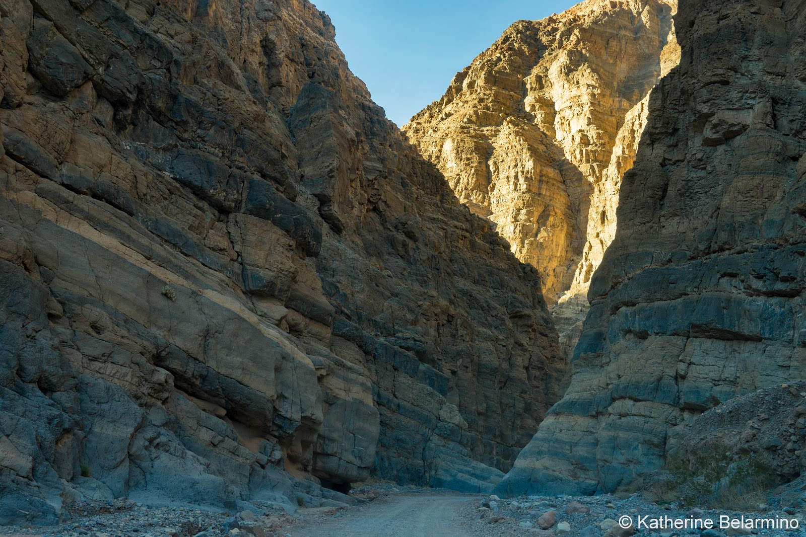

Titus Canyon Death Valley Road Trip Itinerary

Titus Canyon is the most popular back-country road in Death Valley National Park, and it’s easy to see why.  This off-road drive has everything: a ghost town, petroglyphs, mountain views, and a drive through winding canyon narrows.  The drive is one way, from east to west, is 27 miles long, and takes a leisurely two to three hours.  The last three miles are two-way and can be handled by a standard vehicle.  The entrance is on Nevada Highway 374, two miles east of the National Park boundary.

Leadfield Ghost Town Titus Canyon Death Valley Road Trip Itinerary

The ghost town of Leadfield was a mining boom town.  It was one of the shortest-lived mining towns founded primarily on false advertising.  300 people arrived in 1926, and the town was empty by February 1927. 

Klare Springs Petroglyphs Titus Canyon Death Valley Road Trip Itinerary

Klare Spring produces 20 gallons of water a minute which creates a small wetland that bighorn sheep frequent.  The Native Americans also spent time here hunting bighorn and creating petroglyphs in the rocks.  Sadly, today the rocks contain both ancient and modern petroglyphs.

Twenty Mule Team Canyon


Twenty Mule Team Canyon Death Valley Road Trip Itinerary

Twenty Mule Team Canyon is a relatively short (less than 3-mile) unpaved road winding through badlands.  The name comes from the Twenty Mule Teams which pulled huge wagons carrying borax from Harmony Borax Works to the railroad 165 miles away.


What to Drive Off-Roading in Death Valley


2018 Toyota Highlander Hybrid Limited Platinum 4WD

While many of Death Valley’s sites can be seen with any kind of vehicle, Death Valley’s off-road adventures really require a vehicle that’s up to the challenge.  Even Devils Golf Course is reached by a dirt road, though that one can be driven by a standard vehicle.  But the road to Natural Bridge Canyon and the off-road drives of Titus Canyon, Twenty Mule Team Canyon, and Racetrack Playa should really be driven in a high-clearance off-road capable vehicle.  That’s not to say that you won’t see a regular car on those roads, but the likelihood of an issue, like a blown tire, is a risk I wouldn’t want to take.

Titus Canyon Off-Roading 2018 Toyota Highlander Hybrid Limited Platinum AWD

For our trip to Death Valley, we got a chance to test drive the 2018 Toyota Highlander Hybrid Limited Platinum AWD.  I was so thankful to have such a capable vehicle for our off-road drives through Death Valley.  Driving off-road on rocky, washboard, pot-holed dirt roads can be nerve-racking, but we had a high sense of security in the Highlander.  For off-roading, the features that made us feel safe were the high clearance, the tires that could hold up to sharp rocks, and the all-wheel drive.


We drove from San Diego to Death Valley, and even once there we were driving a lot of miles as Death Valley National Park is so huge, so it was fantastic having the hybrid feature which means we could drive a long time before having to fill up with gas.  The interior is also very roomy, with three rows of seats if you have lots of passengers.  Or, if going on a road trip with two people, two dogs, and all of the luggage that such a family requires, the last row of seats folds down, providing plenty of room for luggage, camera equipment, a dog pen, a dog buggy, a cooler, and a set of golf clubs.

Toyota Highlander Hybrid Limited Platinum AWD Offroad

Not that these features helped with the off-roading, but it didn’t hurt that the 2018 Toyota Highlander Hybrid Limited Platinum AWD also had a pretty luxurious interior with features like super soft leather, a panoramic sunroof, heated and ventilated seats, hands-free entry, and Toyota’s birds-eye view.  One feature I particularly enjoyed which was useful for a road trip was the in-dash shelf.  It helped me keep my phone, our itinerary, my camera lens cap, charging cord, GoPro, and whatever else I needed easily and quickly accessible.

Death Valley Pass


Death Valley Road Trip Itinerary

Visitors to Death Valley must purchase a permit.  The vehicle entrance fee ($25 at time of writing) allows all people traveling in a vehicle with a permit to enter and leave the park as many times as they wish during a 7-day period.  There are ranger stations and kiosks in a number of places throughout the park.

Death Valley Weather


Salt Flats Death Valley Road Trip Itinerary

There’s a reason why Death Valley has the word death in its name.  Death Valley gets deathly hot in the summer.  Death Valley has the dubious honor of being the hottest place on earth and having the world record for the highest air temperature of 134 degrees Fahrenheit.  120 degrees in the summer isn’t unusual.  The best months to visit are November through March, though April and October can be tolerable.

Booking.com

Thank you to Toyota for letting us test drive the 2018 Toyota Highlander Hybrid Limited Platinum AWD for our Death Valley road trip.  As always, all opinions are our own.  This article may contain affiliate links.  Purchasing through them costs you nothing extra and we earn a small commission which goes towards running this website and bringing you more travel stories.


Travel the World: A three-day road trip itinerary of the best things to do in Death Valley.

Twin Falls Overlook 1 Self-Guided Photography Tour of Mammoth Lakes

There are a lot of things to do in Mammoth Lakes in the summer like hiking, biking, visiting old mining ghost towns, and more.  One other thing to do in Mammoth Lakes is to simply explore the scenery.  Mammoth Lakes is an incredibly photogenic destination, especially in the summer when the air is warm, the lakes are liquid, and the leaves are green or just starting to turn autumn colors.  When we weren’t enjoying outdoor activities, we were looking for the best photography spots in and around Mammoth Lakes.  Here are some stops to add to your self-guided photography tour of Mammoth Lakes.

Mono Lake at Night


We hadn’t planned our trip to Mammoth Lakes around night photography, so we were a little disappointed when we realized the weekend we had chosen would have a bright moon.  However, while we had very little Milky Way sighting, we did have a moon that lit up the views and made for some amazing pictures, especially at Mono Lake.  We were able to walk the trail from the parking lot to the lake just by the light of the moon and didn’t turn our flashlights on once.  Once at the lake, the tufa towers were perfectly lit by the moon. 

Mono Lake at Night Self-Guided Photography Tour of Mammoth Lakes
Mono Lake Tufa Towers at Night Self-Guided Photography Tour of Mammoth Lakes
Mono Lake Night Self-Guided Photography Tour of Mammoth Lakes

Minaret Vista at Night


Another beautiful nighttime spot is Minaret Vista.  During the day, this area can only be reached by shuttle bus.  But at night, you can drive and explore on your own.  So we drove up Minaret Road to a turnoff just before Minaret Vista.  It’s actually the perfect make-out spot.  But we went for some night photography instead.  From here is a great view of the Minarets, Mount Ritter and Mount Banner.

Minaret Vista at Night Self-Guided Photography Tour of Mammoth Lakes

June Lake Loop


There are a number of short drives in the Mammoth Lakes area that pass photogenic lakes and scenes.  One of those is the June Lake Loop.  The June Lake loop passes by Silver Lake, Gull Lake, and June Lake.

Silver Lake

Silver Lake June Lake Loop Self-Guided Photography Tour of Mammoth Lakes

Gull Lake

Gull Lake June Lake Loop Self-Guided Photography Tour of Mammoth Lakes

June Lake

June Lake Loop Self-Guided Photography Tour of Mammoth Lakes

Mammoth Lakes Basin


Another lake grouping in Mammoth Lakes is the Mammoth Lakes Basin.  There are a number of lakes to visit on this driving loop, including Twin Lakes, Lake Mary, Lake Mamie, and Horseshoe Lake.  A waterfall, Twin Falls, moves water from the higher Lake Mamie into the lower Twin Lakes.  The view of the falls is worth a stop in the Twin Lakes Campground.  Then head up to Lake Mamie not only for a view of the lake, but also to stand at the top of Twin Falls and get an aerial view of Twin Lakes from the Twin Falls Overlook.  Horseshoe Lake is interesting more for the dead trees surrounding it, as a series of small earthquakes in 1989 and 1990 released carbon dioxide from cooling magma which caused over 100 acres of tree kill.

Twin Lakes

Twin Lakes 1 Mammoth Lakes Basin Self-Guided Photography Tour of Mammoth Lakes
Twin Lakes 2 Mammoth Lakes Basin Self-Guided Photography Tour of Mammoth Lakes
Twin Falls Mammoth Lakes Basin Self-Guided Photography Tour of Mammoth Lakes

Lake Mary

Lake Mary Mammoth Lakes Basin Self-Guided Photography Tour of Mammoth Lakes

Twin Falls Overlook

Twin Falls Overlook 2 Self-Guided Photography Tour of Mammoth Lakes

Lake Mamie

Lake Mamie Mammoth Lakes Basin Self-Guided Photography Tour of Mammoth Lakes

Horseshoe Lake

Horseshoe Lake Mammoth Lakes Basin Self-Guided Photography Tour of Mammoth Lakes

Convict Lake


Convict Lake is a lake with a story.   It was formed thanks to glacier activity 10,000 years ago.  The lake was given a different name by the Native Americans, but it gained the name Convict Lake after the famous shootout in September 1871.  Convicts broke out of prison in Carson City, Nevada and six of them made it to the Mammoth Lakes area.  In the shootout, the convicts killed Sheriff Robert Morrison, the namesake of Mount Morrison, and Paiute guide Mono Jim, the namesake of Mono Lake.

Convict Lake 1 Self-Guided Photography Tour of Mammoth Lakes
Convict Lake 2 Self-Guided Photography Tour of Mammoth Lakes

Hot Creek


Hot Creek is a crazy creation of Mother Nature.  Hot Creek bubbles and steams from water heated by lava coming up through crevices in the river floor to mix with the cold snow-melt river water.  Most visitors to Hot Creek visit the Hot Creek Geological Site, and there are some great photo opportunities here.  However, there are some other interesting photo spots farther north up Hot Creek Hatchery Road and off of Owens River Road where the road crosses Hot Creek.  In these places, you can see Hot Creek wind through the flat landscape.

Hot Creek 1 Self-Guided Photography Tour of Mammoth Lakes
Hot Creek 2 Self-Guided Photography Tour of Mammoth Lakes
Hot Creek 3 Self-Guided Photography Tour of Mammoth Lakes
Hot Creek 4 Self-Guided Photography Tour of Mammoth Lakes
Hot Creek 5 Self-Guided Photography Tour of Mammoth Lakes

Thank you to Visit Mammoth and Mitsubishi for hosting our summer Mammoth Lakes weekend getaway and making this post possible.  As always, all opinions are our own.
Travel the World: A self-guided photography tour of Mammoth Lakes, including Mono Lake, Minaret Vista, June Lake Loop, Mammoth Lakes Basin, Convict Lake, and Hot Creek.

Desert Sunflowers Henderson Canyon Road Southern California Anza-Borrego Desert Wildflowers
Field of desert sunflowers along Henderson Canyon Road.
I’ve lived in San Diego my entire life and I grew up going to the desert, including Anza-Borrego State Park, multiple times every year.  I do not ever remember seeing the Anza-Borrego wildflowers in bloom like they are this year.  I vaguely remember hiking with my mom and keeping our eyes peeled for the occasional desert bloom.  But this year, because of the insanely above-average rain we’ve received in Southern California, the desert wildflowers are out in full force in Anza-Borrego.  In fact, they’re saying this may be the biggest super bloom in 20 years.

Peg Leg Road Southern California Anza-Borrego Desert Wildflowers
Desert wildflowers along Anza-Borrego's Peg Leg Road.
If you’re in Southern California, you’ll want to get out to Anza-Borrego as soon as possible to see the fields of desert wildflowers, because they’re not going to last very long.  The delicate flowers will only last as long as the sun, wind, and caterpillars will allow.

Barrel Cactus Southern California Anza-Borrego Desert Wildflowers
Barrel Cactus in bloom.
Bigelow's Monkeyflower Southern California Anza-Borrego Desert Wildflowers
Bigelow's monkeyflower.
Brown-Eyed Evening Primrose Southern California Anza-Borrego Desert Wildflowers
Brown-eyed evening primrose.
Creosote Bush Southern California Anza-Borrego Desert Wildflowers
Blooming creosote bush.
Desert Chicory Southern California Anza-Borrego Desert Wildflowers
Desert chicory.
Desert Dandelion Southern California Anza-Borrego Desert Wildflowers
Desert dandelion.
We visited Anza-Borrego on Sunday, March 12, 2017.  We were worried it would be incredibly crowded as it was the weekend, plus we got a late start thanks to daylight savings time.  However, while there were more people than I’ve ever seen in Anza-Borrego, there was always plenty of space to park, even in the more popular spots, so don’t let the thought of weekend crowds scare you if you have to work during the week.  It was crazy how many people were out with their cameras.  We decided we haven’t seen that many cameras in one place, even in the touristiest places in Europe.

Desert Lily Southern California Anza-Borrego Desert Wildflowers
Desert lily.
Desert Sunflower Southern California Anza-Borrego Desert Wildflowers
Desert sunflower.
Dune Evening Primrose Southern California Anza-Borrego Desert Wildflowers
Dune evening primrose.
Ocotillo Southern California Anza-Borrego Desert Wildflowers
Ocotillo.
Popcorn Flower Southern California Anza-Borrego Desert Wildflowers
Popcorn flower.
Sand Verbena Southern California Anza-Borrego Desert Wildflowers
Sand verbena.
Using a map on the DesertUSA website, we chose to search for the Anza-Borrego wildflowers along Henderson Canyon Road and Peg Leg Road.  We also found some good wildflowers that were a little bit different along Yaqui Pass Road.  The desert wildflowers we found included purple sand verbena, yellow desert sunflower, white desert lily, desert dandelion, brown-eyed evening primrose, dune evening primrose, popcorn flower, Bigelow’s monkeyflower, desert chicory, barrel cactus, ocotillo, and creosote. 

Caterpillar Southern California Anza-Borrego Desert Wildflowers
Wildflower eating caterpillar.
This size of super bloom of desert wildflowers doesn’t happen every year, so if you get the chance, take a drive to Anza-Borrego as soon as possible.

Travel the World: Wildflowers in Southern California's Anza-Borrego desert.

MKRdezign

Formulir Kontak

Nama

Email *

Pesan *

Diberdayakan oleh Blogger.
Javascript DisablePlease Enable Javascript To See All Widget